Name of Unit |
imedtac Co., Ltd. |
Hyperlink |
https://www.imedtac.com/en/ |
Name of Application Service |
The policy of Ministry of Public Health 2024 - Primary Care Project ( Thai 4.0 ) |
||
Name of the Collaborative Group |
Prachin Buri province, Thailand |
Hyperlink |
|
Application Field Description |
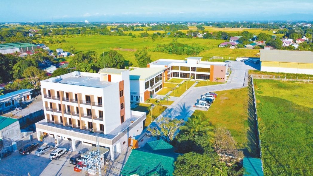
Prachin Buri province is located in eastern Thailand, about a 4-hour drive from Bangkok. The people here are still mainly engaged in agriculture so their income is relatively limited. There are still problems with insufficient educational and medical resources, making it difficult to go to the Greater Bangkok area for medical treatment. Based on the local conditions, Prachin Buri province is prioritized as the promotion area for Primary Care by the Thai Government. The application field is the local district hospital, the primary medical service unit in rural areas and is responsible for providing Primary Care to the people. |
||
Brief of Innovation and Achievement |
The program's main purpose is to establish a vital signs measurement system and telemedicine system in health centers in rural areas of Thailand. imedtac’s Smart Healthcare Station has voice and animation guidance so people can measure by themselves without the help of medical staff which reduces the use of medical manpower. The Smart Healthcare Station also uploads the data to the Ministry of Public Health of Thailand's health system and syncs with the government financial institution system to facilitate the verification and reimbursement of medical institutions, such as clinics and hospitals. Through technology, medical resources from metropolitan areas can be delivered seamlessly to remote areas at the lowest cost. |
||
Challenges and Solutions for the Application’s Deployment |
Since the application field is a rural district, the infrastructure remains undeveloped in many areas, including clinics and hospitals. l Unstable local network and power systems: Compared to the products selling in Taiwan, UPS equipment is required to maintain basic operations during power outages or unstable power conditions and avoid equipment damage. l Unfamiliarity with smart medical care processes: Local residents are unfamiliar with self-service AIoT systems. Therefore, auxiliary personnel are required to assist. However, with the built-in instructions, it didn’t take too long for them to learn how to use the system. l System maintenance challenges in remote areas: build the remote device operating and monitoring system. Therefore, engineers in Taiwan can check whether the system functions normally. The system significantly reduces possible maintenance costs and resolves the problems promptly.
Video: imedtac’s Primary Care Case: Telemedicine Solution and Health Equity in Thailand |
Name of Unit |
E-Formula Technologies, Inc. |
Hyperlink |
https://www.e-formula.com/ |
Name of Application Service |
Bohol Net-Zero Transformation Project: A Five-Pillar Energy Approach – Energy Conservation, Green Electricity Production, Energy Storage Solutions, Electric Vehicle Charging Network, and Intelligent Energy Management System. |
||
Name of the Collaborative Group |
Bohol Province, Philippines |
Hyperlink |
https://bohol.gov.ph/ |
Application Field Description |
1. Scope of Application: Bohol Island, Philippines: Approximately 3,269 square kilometers in area, with a coastline length of 261 kilometers. It is the tenth largest island in the Philippines, with a population of about 1.13 million.
2. Current Situation Analysis of Bohol Province: (1). Energy Overview: The total electricity demand on the island is 132.4MW, of which 90MW (approximately 68%) relies on external power supply. Of the remaining 42.4MW (approximately 32%), 34MW (approximately 26%) comes from fossil fuels, with only 8.4MW (approximately 6%) from renewable energy sources. Additionally, the Janopol hydropower plant, contributing 5.0MW, was submerged in a recent typhoon and is now inactive. Therefore, there is an urgent need for infrastructure investment in local power supply and transitioning to a net-zero power source. (2). Industry Overview: The main industry in Bohol Province is tourism. Although it has not yet fully recovered to the pre-COVID-19 level of 1.5 million visitors annually, the province was designated as a UNESCO Global Geopark in 2023, and tourist numbers are expected to gradually exceed pre-pandemic levels. Promoting sustainable tourism and ensuring stable power supply have thus become crucial for local economic development.
3. Project Benefits: (1). Assisting in stabilizing local power supply. (2). Providing zero-carbon electricity. (3). Supporting the development of sustainable tourism industry and local economy, creating job opportunities. |
||
Brief of Innovation and Achievement |
This project will empower Bohol, Philippines to achieve its net-zero transition by deploying a suite of integrated energy solutions. These include establishing solar, wind, and hydro power generation facilities; producing sustainable aviation fuel; implementing waste-to-energy systems; integrating electric vehicles with bidirectional charging infrastructure; and leveraging hydrogen fuel cell technology. The successful implementation of these initiatives will generate significant carbon credits. |
||
Challenges and Solutions for the Application’s Deployment |
In order to secure the support of the Japanese and Philippine governments, Chodai Corporation of Japan is well aware of our company's past accomplishments and capabilities in the Philippines. They have extended a special invitation for our collaboration on this project, leveraging the strengths of both parties to facilitate bilateral cooperation. Through diligent investigation, research, and negotiations on both sides, we successfully persuaded the Japanese government and obtained approval from the Japanese government in the form of an approval letter.
There are cultural differences in construction and operational planning between Taiwan and the Philippines, which have posed challenges in project execution. These difficulties can be overcome through cross-cultural training, establishing collaborative planning and execution mechanisms, prioritizing document and on-site management, appointing communication coordinators from both sides, and implementing flexible processes. |
Name of Unit |
Wave-In Communication Inc. |
Hyperlink |
https://www.wavein.com.tw/ |
Name of Application Service |
The Deployment of 5G Command Center with Mission-Critical Heterogeneous Network |
||
Name of the Collaborative Group |
UNITED GLOBAL TECHNOLOGIES Pte. Ltd. |
Hyperlink |
|
Application Field Description |
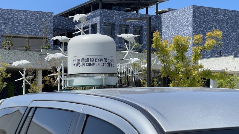
Wave-In provides a mission-critical heterogeneous network integration solution, integrating 5G core networks, ORAN, and NGSO satellite links. Combined with Wave-In's independently developed software and hardware, it ensures seamless signal coverage through stable services delivered by optical fiber communication. This integration forms a comprehensive E2E 5G base station and core network application solution. The solution offers a cost-effective, easy-to-install, and high-performance resilient network to support the deployment of 5G critical mission command centers. |
||
Brief of Innovation and Achievement |
l Command Center l Mission-Critical Heterogeneous Network Integration l Multi-Generation (Multi-Gth) Indoor Signal Coverage Solution l Flexible and Rapid DAS System Deployment
|
||
Challenges and Solutions for the Application’s Deployment |
l Communication Upgrade l Cost Reduction l Shortened Construction Period
|
Name of Application Service |
The Great Decoding of Building Carbon Emissions: The Low-Carbon Revolution from Models to Reality – Low-Carbon Building (BIM Model) Assessment System |
Name of Unit |
Public Works Department, New Taipei City Government |
Hyperlink |
|
Name of the Collaborative Group |
Chinese Public Works Engineering Information Association |
Hyperlink |
|
Brief of the Application or Service |
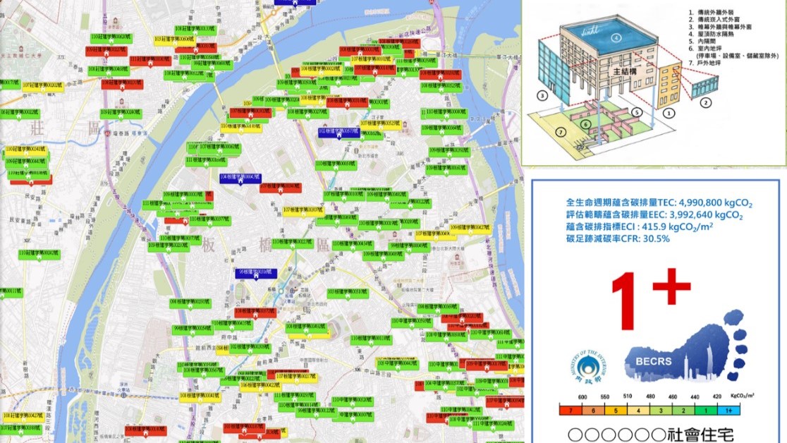
1. As the governing body for building development, we are committed to achieving Mayor Hou You-Yi's promise of reducing carbon emissions by 30% by 2030 and achieving net-zero carbon emissions by 2050. To facilitate lifecycle carbon disclosure and net-zero building goals, this system integrates BIM (Building Information Modeling) technology with the Ministry of the Interior's Low Em-bodied-carbon Building Rating System (LEBR) and its building component carbon footprint database. It enables architects to pre-assess carbon emissions during the planning stage, accelerating industry transformation towards carbon reduction at the source. 2. This application enhances New Taipei City's Building Permit Computerized Review System by incorporating low-carbon (embodied carbon) building evaluation and calculation functionalities. Users can upload BIM models without restrictions on specific modeling software, link materials to carbon emission data, and automatically analyze and calculate carbon emissions for each building component. 3. Application or Service (1) Streamlined Carbon Assessment Workflow: Integrates BIM with standardized LEBR carbon footprint calculations for operational efficiency. (2) Source Carbon Reduction: Enables real-time carbon evaluation for architectural plans, maximizing the carbon reduction potential at the design stage. (3) Building Carbon Footprint Disclosure: Displays carbon footprint data and evaluation grades on GIS platforms, starting with public buildings as demonstration projects. PS: Caption 1: Workflow of the Low-Carbon Building (BIM Model) Evaluation System Caption 2: Core Framework of the Low-Carbon Building (BIM Model) Evaluation System Caption 3: Low Carbon (Embodied Carbon) Carbon Footprint Disclosure |
Brief of Innovation Initial and Achievement |
Caption 4: New Taipei Trial Sites Have Inherent Advantages and Potential Caption 5: At the 2024 "New Taipei Net-Zero BIM Action" Seminar, the academic sector invited Professor Hsieh Shang-Hsien from the NTU BIM Center, Professor Lin Hsien-Te, and Associate Professor Yang Shih-Hsien from National Cheng Kung University to discuss BIM applications in net-zero sustainability development, technical services, fee structures, and carbon reduction evaluations during the design phase, as well as carbon emission calculations for road engineering (PCCES analysis). From the industry sector, we invited Continental Engineering Corporation, Chinese Public Works Engineering Information Association. Taipei International Group(Architectural firm), and Huakang Ennowell Intelligent Cloud to present BIM applications in architecture and public works, focusing on case studies integrating net-zero carbon strategies. Caption 6: The Ministry of the Interior's Architecture and Building Research Institute Implemented the Low-Carbon (Embodied Carbon) Building Evaluation Manual on January 1, 2024. |
Challenges and Solutions for the Application Deployment |
This system leverages BIM models to automate large-scale data analysis for calculating carbon emissions and generating carbon footprint reports. Although AI technology is not directly applied, the system incorporates the embodied carbon formulas and building carbon footprint component database from the Ministry of the Interior's Architecture and Building Research Institute, offering a reliable tool for low-carbon building evaluation (Figures 7-9). Caption 7: Excerpt from the Formulas in the Low-Carbon (Embodied Carbon) Building Evaluation Manual by the Architecture and Building Research Institute Caption 8: Excerpt from the Formulas and Carbon Emission Material Database in the Low-Carbon (Embodied Carbon) Building Evaluation Manual Caption 9: The system utilizes the formulas from the Building Evaluation Manual and automates data processing via BIM models to calculate carbon emissions and generate carbon footprint reports. |
Innovation Index |
Reducing carbon emissions at the construction source yields the best results (Figure 15). Utilizing the BIM + Carbon Reduction Evaluation System. Free 24-hour access for architects to upload BIM models for self-assessment (Figure 16). The system's innovation lies in combining BIM technology with the low-carbon building evaluation mechanism, enabling automated carbon emission calculations. Compared to traditional manual methods, this system improves work efficiency and reduces errors. Additionally, the system offers a visualized BIM model display of carbon emissions, allowing users to intuitively verify carbon-emitting materials and data, perform real-time calculations, and generate carbon emission reports (Figure 17).
Caption 15: Effective Carbon Reduction at the Construction Source Caption 16: Using the BIM + Carbon Reduction Evaluation System Caption 17: The Drive Toward Net-Zero Carbon Will Shape Digital Twin Cities Figure 18: Project Implementation Timeline |
Future Plan |
2024: Public Sector Leads the Way – Development of a Low-Carbon Building Verification System using BIM technology, piloting with public buildings nationwide to initiate building carbon reduction efforts. 2025: Public and Private Collaboration – Encouraging private projects to adopt the low-carbon building verification system to evaluate embodied carbon. 2026: Data Transparency – Establishing New Taipei City's LEBR Building Open Data Platform to implement full carbon emission disclosure, with periodic reviews of implementation methods and timelines.
|
Name of Application Service |
Nation's First AI Human Form Recognition System: "Loudspeaker Rescuer" Safeguards Public Safety |
Name of Unit |
Tourism Information Department, Chiayi City Government |
Hyperlink |
|
Name of the Collaborative Group |
Fire Bureau, Chiayi City Government Police Bureau, Chiayi City Government Enterprise Business Group, Chunghwa Telecom Co., Ltd. Taiwan Sing Po Security Co., Ltd. |
Hyperlink |
|
Brief of the Application or Service |
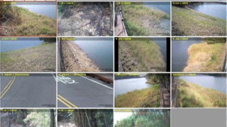
To ensure the safety of the Lantan Reservoir and prevent unauthorized access to restricted water areas, the Chiayi City Government has implemented the "Water Area AI Human Form Recognition System" across six key hotspots along the Lantan Lake Circular Trail. Equipped with 19 surveillance cameras, the system actively detects human presence in restricted water zones. Once detected, a "Loudspeaker Rescuer" system broadcasts real-time verbal warnings to immediately deter individuals, effectively preventing potential accidents. This project integrates water safety measures, geofencing, human activity recognition, edge computing technology, communication software, and on-site broadcasting equipment into a comprehensive system. The system is connected to a security company's control center for centralized monitoring and response. In case of emergencies, rescue requests can be promptly relayed to the Police and Fire Bureaus. This innovative solution has significantly reduced incidents of public encroachment into restricted water areas and is the first of its kind in the nation. The Chiayi City Government demonstrated exceptional cross-sector integration and communication collaboration capabilities, successfully facilitating an interdisciplinary partnership to develop an innovative water safety solution. This groundbreaking initiative has earned the prestigious "2025 Smart City Innovative Application Award." Although various agencies are partially involved in water safety operations, integration across these units has proven to be a challenge. Illustration of challenges in this project |
Brief of Innovation Initial and Achievement |
Lantan Reservoir, spanning 70 hectares, serves as a vital recreational hub and a crucial water source for Chiayi City. Renowned for its scenic beauty, often referred to as "Lantan Reflecting the Moon", the reservoir has unfortunately been associated with frequent incidents of people falling into the water and various eerie, unfounded local legends. These factors have contributed to negative perceptions, impacting Chiayi City's tourism brand and overall urban image. This project, based on statistical data from the Fire Bureau Duty Command Center, involved the installation of 19 human activity recognition systems and loudspeaker broadcast systems across six high-risk drowning zones around the Lantan Reservoir. These systems were also integrated with private security companies. With a modest investment of NT$2.1 million, since its launch on April 1, 2024, the average monthly number of people inadvertently entering the water has decreased significantly by 34.6 times, effectively reducing both the frequency of fire and rescue personnel dispatches and the likelihood of drowning incidents at the source. This project demonstrates high scalability and replicability, inspiring adoption by the Taichung City Government, Tainan City Government, and Kaohsiung City Government, all of which are preparing to implement similar water safety prevention measures. In addition to enhancing public safety by saving lives, this initiative also boosts the potential market opportunities for Taiwan's image recognition industry, further driving innovation and development in this sector.
|
Challenges and Solutions for the Application Deployment |
I. Challenges Encountered: (I) Complex administrative management: At least five different land management agencies oversee areas surrounding the Lantan Reservoir. (II) Frequent false alarms: Infrared blocking equipment is highly susceptible to environmental factors, reducing accuracy. (III) Water range definition: Significant fluctuations in reservoir water levels make it challenging to define monitoring boundaries. (IV) Limited workforce: Public service personnel are insufficient to manage the vast water area effectively. II. Solutions Implemented: (I) Cross-agency coordination and integration: Established the primary management unit for the site as the competent authority; conducted on-site drills. (II) Human form recognition system: Adopted advanced technology after visiting the Smart City Summit & Expo, introducing mature and reliable image recognition systems. (III) Reference data: The system dynamically adjusts its monitoring range according to water level fluctuations, ensuring precise and effective surveillance. (IV) Outsourcing to security firms: A professional security service provider offers 24/7 monitoring and alert capabilities, significantly reducing the burden on public sector personnel.
|
Innovation Index |
(I) Nationwide first: Integrating geofencing, human form recognition, communication software, and loudspeaker systems, this innovative approach has set a benchmark, inspiring widespread adoption across various sectors. (II) Cross-sector collaboration: The project brings together diverse teams from tourism, police, and fire bureaus, as well as private security firms. (III) System architecture: Utilizing edge computing, wireless transmission, and cloud storage, the system is developed around an AI-based image recognition module for enhanced accuracy and functionality.
The project was featured as a cover story in the March issue of the Fire Safety Monthly
Kaohsiung City Government representatives and Chiayi City Government team in a group photo. Tainan City Government representatives and the Chiayi City Government team in a group photo. |
Future Plan |
To further monitor public activity in and around the water areas, additional 360-degree panoramic cameras will be installed, complemented by the establishment of a robust fiber optic network to expand monitoring coverage and ensure sufficient bandwidth. Drawing on the experience gained from this project, similar systems will be implemented along bicycle paths to prevent unauthorized motor vehicles from entering. Beyond recognizing "human forms," the system's capabilities will also extend to identifying incidents involving unauthorized entry by vehicles such as cars, motorcycles, and bicycles. |
Name of Application Service |
AI-Based Ship Recognition and Smart Tracking Monitoring System for Port Areas |
Name of Unit |
Taiwan SECOM CO., LTD. |
Hyperlink |
https://www.secom.com.tw/en |
Name of the Collaborative Group |
|
Hyperlink |
|
Brief of the Application or Service |
This system has five key functions: 1.AI Recognition & 24/7 Monitoring: Identifies ship types, tracks vessels automatically, and switches cameras for recording, enhancing efficiency and safety. 2.AI Auto-Tracking: Automatically calls cameras to follow ships upon entry, stopping when docked, boosting automation. 3.AIS with PTZ Cameras: Uses AIS GPS data to auto-track ships with PTZ cameras, ensuring precision even in bad weather. 4.AIS Data & Violation Detection: Monitors speed, coordinates, and heading to detect violations (e.g., speeding, collisions), alerting controllers. 5.OSD Display & Alerts: Displays AIS data on monitoring screens and provides real-time alerts for violations. The developer integrates AI, AIS, and camera controls, ensuring stable performance in all conditions, reducing errors, and enhancing port safety. |
Brief of Innovation Initial and Achievement |
This system uses AI and AIS to transform traditional ports into smart ports, covering ship monitoring, violation detection, and safety management, adaptable to all port sizes and other hubs. Key Features: 1.Real-Time Monitoring: Tracks and categorizes ships with AI and AIS. 2.Safety Management: Detects speeding, collisions, and issues alerts. 3.All-Weather Monitoring: Accurate tracking day, night, or in harsh conditions. The system automates camera controls for 24/7 monitoring, reducing manual workload and aiding quick decision-making while providing evidence for incidents. It also drives job creation in AI, analytics, and boosts industries like smart transport, creating economic and technological growth. |
Challenges and Solutions for the Application Deployment |
Implementing smart ship recognition systems faces challenges in technology, infrastructure, and personnel:
1.Data Integration: Existing systems lack interoperability. Standardized tools and APIs ensure real-time data exchange, reducing errors. 2.AI Accuracy: Diverse weather and ship types affect AI. Regular training with varied datasets improves performance. 3.Weather & Night Precision: Poor visibility reduces image quality. Integrating AIS coordinates ensures accurate tracking in adverse conditions. With careful planning and innovation, these challenges can be overcome to improve port efficiency, reduce risks, and achieve long-term economic benefits. |
Innovation Index |
Smart ports integrate AI and big data to boost efficiency and safety: 1.Auto Tracking: AI identifies and tracks ships, reducing manual effort. 2.All-Weather Monitoring: AIS with PTZ cameras ensures precise tracking in poor conditions. 3.Violation Detection: Detects overspeeding, drifting, or illegal docking. 4.Decision Support: Combines AIS data and images for quick, informed decisions. 5.Cost Efficiency: Automation reduces labor costs and improves turnaround time. This system drives ports toward smart, competitive global operations. |
Future Plan |
Smart ports hold great potential: 1.Smart City Integration: Seamless supply chain connections. 2.Smart Traffic: Optimized port traffic management. 3.Global Networking: Real-time data sharing among ports. 4.AI Analytics: Predict demand and issues for agile responses. 5.Blockchain: Transparent, secure cargo tracking. These innovations make ports efficient, sustainable global hubs. |
Name of Application Service |
SAFE SWIM System |
Name of Unit |
Taichung City Government |
Hyperlink |
https://www.taichung.gov.tw/ |
Name of the Collaborative Group |
Fortune AI Technologies Co., Ltd. |
Hyperlink |
www.safeswim.io |
Brief of the Application or Service |
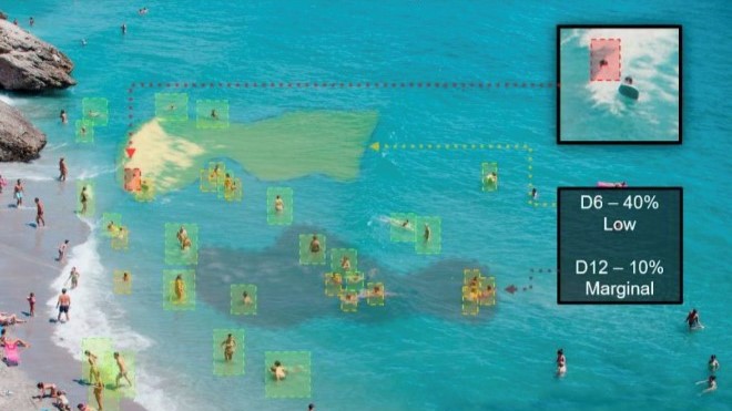
This service is an AI-based water safety monitoring solution that integrates with existing surveillance systems to provide 24/7 behavior monitoring and abnormality notifications. The system supports multi-camera perspective tracking and multi-zone alerts, enabling quick detection of potential drowning risks and offering real-time warnings to prevent accidents. |
Brief of Innovation Initial and Achievement |
The service has undergone pilot applications in commercial swimming pools, sports centers, and various government water facilities. It is particularly suitable for public and private pool environments. Pilot locations include multiple swimming facilities in Taiwan, Asia, and Europe, achieving comprehensive monitoring and abnormal behavior notifications to enhance water safety management efficiency. |
Challenges and Solutions for the Application Deployment |
Challenge: The accuracy of traditional visual surveillance systems is low in scenarios with water surface reflections, ripples, and crowding. Challenge: High demand for multi-camera configuration and on-site adjustments. |
Innovation Index |
Technological Innovation: An AI swimming pool safety monitoring system based on multi-camera perspectives, supporting up to 100% coverage and real-time warnings. |
Future Plan |
Future Plan: Expand the market to Asia, the Americas, and Europe, occupying a significant share of global water safety solutions. Launch new product lines for households and outdoor water areas, such as AI module licensing and wearable devices. |
Name of Application Service |
Recovering Serenity: Revolutionizing Peaceful Living with Advanced AI Noise Reduction Technology |
Name of Unit |
Taoyuan City Police Department |
Hyperlink |
https://www.typd.gov.tw/ |
Name of the Collaborative Group |
BOVIA Co. Ltd. |
Hyperlink |
Bovicloud.com |
Brief of the Application or Service |
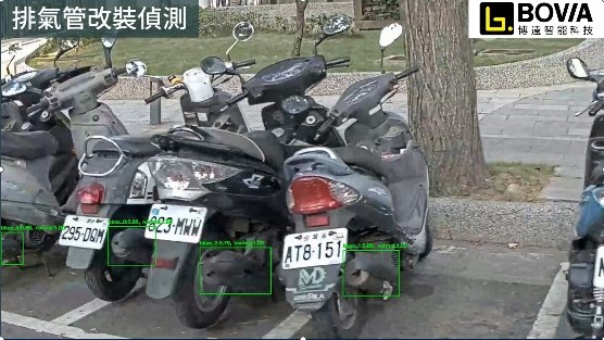
The Taoyuan City Government has discovered that most modified vehicles inspected exceed noise limits, posing significant enforcement challenges. The goal is to reduce noisy vehicles through source control, using sensors and high-resolution cameras for evidence-based enforcement, thus enhancing efficiency and credibility. The Taoyuan City Police Department, in collaboration with the Environmental Protection Bureau, launched the "Silent Peach Project" to crack down on racing and noisy vehicles. By integrating AI technology to identify modified exhaust pipes, they aim to enhance enforcement precision. This system is designed to create a quiet, comfortable living environment and improve citizen satisfaction.
System Application, Services, and Functions The system uses an AI-based modified exhaust pipe identification system. Services include cross-departmental and cross-agency cooperative enforcement, equipment procurement, inspections, and joint investigations. The Taoyuan City Police Department plays a leading role in developing and implementing this system, ensuring fair and just enforcement, maintaining the quality of life for citizens, and fostering a peaceful and pleasant community. |
Brief of Innovation Initial and Achievement |
The Taoyuan City Police Department, in partnership with BOVIA Co. Ltd., has launched the nation's pioneering AI patrol system after an eight-month development period. This innovative system enhances automation, increases the accuracy of identifying moving vehicles, and reduces costs, addressing issues like inadequate traffic monitoring coverage. By integrating AI technology into law enforcement equipment, Taoyuan City leads the way with the addition of an "AI modified exhaust pipe identification" feature to eight police motorcycles, creating a comprehensive "AI patrol protection network." The system boasts functions such as vehicle identification, trajectory tracking, and automatic alerts with voice warnings on terminal devices.
The automation and data collection capabilities of this technological enforcement not only save human resources and time but also overcome the drawbacks of traditional methods, where officers spend substantial time waiting on site. This significantly enhances enforcement efficiency and reduces costs, making it a wise utilization of municipal resources. |
Challenges and Solutions for the Application Deployment |
Detection in Motion and Changing Ambient Lighting: Collect footage from various scenarios and weather conditions. Use data augmentation techniques such as rotation, cropping, scaling, color adjustment, and adding noise to enhance training data. Real-Time Multi-Vehicle Recognition Under High Load: Optimize the model parameters and architecture by leveraging knowledge distillation to enable smaller models to retain the capabilities of complex models, making them suitable for mobile devices or embedded systems. |
Innovation Index |
Cutting-edge mobile edge recognition for modified exhaust pipes, achieving practical deployment with high performance and accuracy levels.
|
Future Plan |
Make full use of patrol resources to establish cross-departmental collaboration, expanding applications for mobile patrol recognition and maximizing cooperative efficiency. |