

Taoyuan Fire Department
Government Innovation Application Group
Mercuries Data Systems Ltd
1. The electronic disaster information:
In the past, fire and rescue work are every minute counts , we need to carry all kinds of disaster relief plans and emergency plans manual, which arrived at the scene and then by the staff to retrieve building plans, water distribution. If it is a storage goods of chemicals or dangerous places, we also need to ask staffs, read material safety information table and other hazards identification information to avoid expanding the fire by disaster or chemical hazards. The fire department has integrated command dispatch, security inspection, source of water and chemical disaster information system into APP. We also use 4G technology to accelerate data transmission and efficiency.
2. The combination of automatic navigation system and Google Street View:
It is the lead to integrate with Google web platform that is including Google Street View and automatic navigation function. It can provide the best path and remove the blind spot address, when firefighters are on their way to understand environment surrounding the buildings and have more time to save people on their rescue operation.
3. To support decision of disaster rescue action:
It can support commanders to have water resources of disaster relief and show the capability of fire trucks and manpower who can make decision in place. With the relief water source image information that can be pre-planned number of deployment and the deployment of people and vehicles and tasks assigned to assist the commander of strategic planning and rescue deployment and strive for rescue time to ensure that firefighters relief and security.
4. In order to enhance the effectiveness of disaster relief, in the event of disaster can fully grasp the site disaster relief information, in addition to integrating their own development of the disaster relief system, will also be related to complete the development of the system connected to the Fire Department APP, (The elderly living alone and the physically and mentally handicapped), the location of Taoyuan MRT station, the positioning of Taoyuan MRT station, the location of Taoyuan MRT station, and so on, with a minimum of Funds to achieve the best relief effect, in order to strengthen the disaster relief energy.
Taoyuan Fire Department is responding with Global Environmental Change which is built to powerful information platform for disaster relief management.
1. The case information: It can control the emergency situation from citizen call 119 in first time that are the name of the person who call, the telephone address, the type of case and so on.
2. The information of attendance vehicle: It can provide commander to dispatch fire trucks. From first fire vehicles on assignment to the other all kinds of support vehicles, it shows as list and type of the reference.
3. The map information of Emergency Sites: The commanders can use this app to understand where is resource of water far away within 1 mile from emergency sites. It combined with google maps and have the location to show in the appliance.
4. Path planning and automatic navigation: It will really quick send firefighters to arrive emergency site because the smart app can show the accurate position and path.
5. Location Street functions: In order to quickly understand the view of emergency scene, commanders can use this function leisurely to arrange such as iron doors, bars or small roadway, water shortage and high voltage wire.
6. Upload the case photos: Attendance firefighters can use APP upload photos, so that the command center can read it immediately. If command center click on the photos, they can understand the situation and increase or decrease vehicles base on the scene.
7. The Building information: The App is interface "National Building Management System" that can query all of the city's building information, including floor graphic information, can be used as a reference for disaster relief personnel burglary.
8. Water resources: The App show the most important water resources near emergency sites, it can provide commanders to plan how to use that for rescue.
9. the information of Narrow alley : In order to avoid disaster relief vehicles can not go through the narrow lane, the app can show the information of Narrow alley if enter the emergency address.
10. Information of Fire Control Equipment: If the affected place is a fire control place, the platform can be used to obtain information about the place (including building structure, floor area, management right, fire prevention management People, the number of types of fire equipment, maintenance declaration information, etc.), but also shows near 200 meters within the tube place, according to anti-disaster relief resources needed to provide defense mechanism.
11. Public Hazardous Substance Information: The user can view the Material Safety Data Sheets and Emergency Response Information for the hazardous materials.
12. Information on Place of Evacuation Vulnerable Groups: Establish information about places where disadvantaged groups are provided by the Social Bureau so that commanders can formulate rescue tactics to evacuate asylum-seekers and evacuate them, so as to ensure that vulnerable groups can avoid obstacles to escape due to inconvenience.
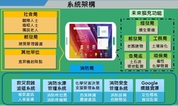
Picture 1.
Description: The system architecture spans that the relevant units to strengthen the information needed for disaster relief.
Picture 2
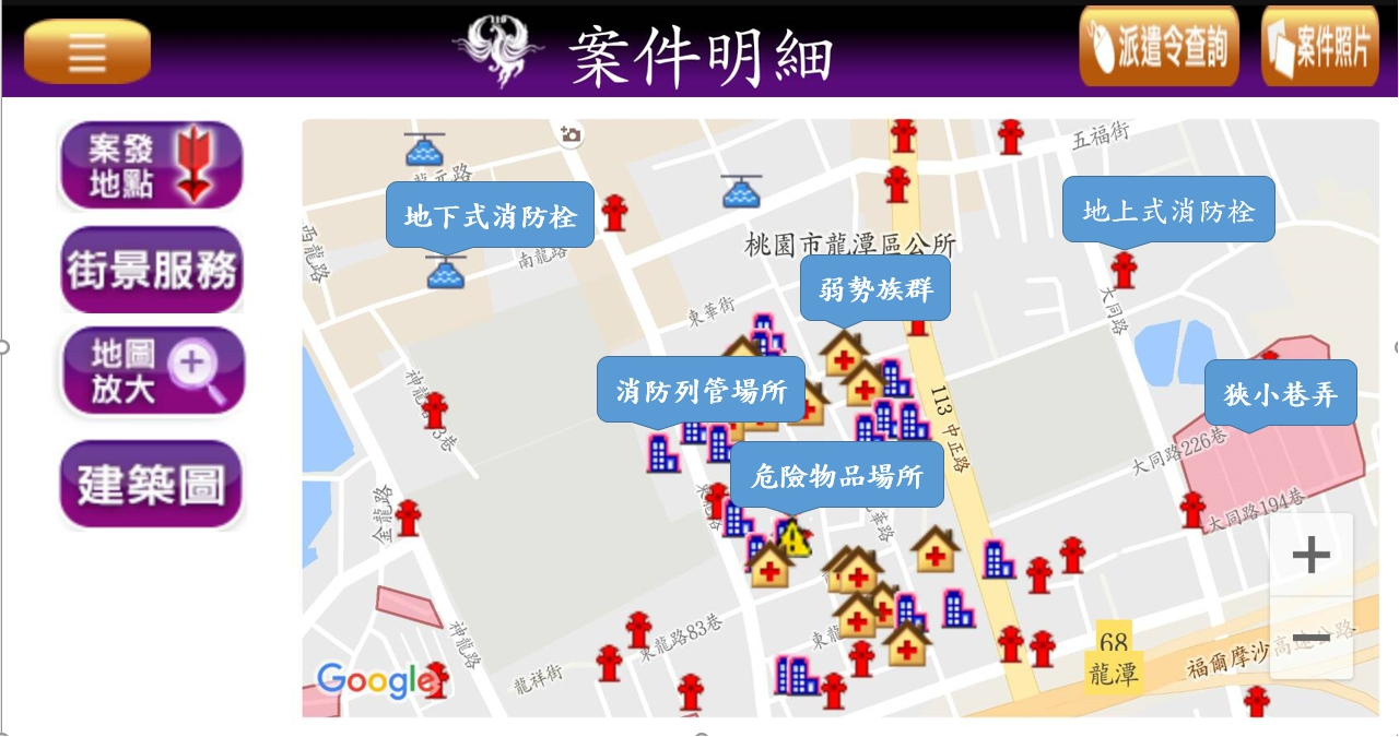
Description: Show the information needed to rescue the surrounding area for the commander and colleagues for use.